PM’s estate linked to land at Fangaʻuta Bridge landing as family disputes Government account
Government records say land at the northern end of the bridge went back to the estate holder. The family says the paperwork was never signed. The survey figures match the Government’s numbers almost exactly.
By Tuífua Vailena, Co-Editor · Oct 25, 2026
NUKUʻALOFA, TONGA: For almost 20 years, Mesia Fauolo says her family tried to get one signature.
In 2006 her late husband applied to give up part of the family’s land so it could pass to their second son. Cabinet approved it. But she says the estate holder, Lord Fakafanua, never signed the papers.
Today that land sits at ʻUmusī, the northern end of the Fangaʻuta Lagoon Bridge. Lord Fakafanua is now Prime Minister.
Documents filed with the Asian Development Bank (ADB), which is funding the project, show the Government says the land was surrendered in 2007 and went back to the estate holder. The family disputes this.
Following TIN’s first investigation into the bridge’s land and design problems, this report looks at one piece of land at the centre of the dispute.
The Government’s own figures, and two land surveys seen by Tonga Independent News (TIN), raise three questions. Who owns the land? Why did the bridge route change in 2026? And did the Prime Minister play any part in decisions touching land linked to his estate?
A signature that never came
According to an account by Mr Lavulavu of 88.1FM who spoke with the widow, she told him that the then Minister of Lands, Lord Tuita, accepted the Fauolo family’s application, lodged on 7 September 2006, to surrender part of their land. Cabinet approved it on 10 January 2007 under Decision No. 49.
The family says the surrender had one purpose: to give that piece of land to the couple’s second eldest son, Roy Salakielu Fauolo.
In Tonga, the eldest son is automatically the heir to all land held by his father. It passes down the line in order. A father who wants a younger son to have land of his own can surrender part of his allotment so it can be granted to that son, with the heir’s approval. The estate holder has to sign off for this to happen.
The eldest son and heir, Major Tuʻifaletahi Fauolo, signed his approval. The family says the only signature missing was the estate holder’s.
The family says the land was never meant to go back to the estate holder. It was meant for Roy.
Mrs Fauolo told Mr Lavulavu of 88.6FM the estate holder never signed the surrender documents. She said the family asked many times over the years, without success.
The family says the missing signature meant the arrangement was never completed.
TIN has not yet seen the Cabinet decision itself.
The family’s complaint
On 14 June 2026, Major Tuʻifaletahi Fauolo the eldest and hier to the property lodged a complaint with the bridge project. He said part of his family’s land had been taken unlawfully. He also raised compensation and asked to deal directly with the Government, not through middlemen.
The complaint is recorded in the project’s Environmental and Social Monitoring Report, filed with the ADB.
The Ministry of Infrastructure’s Project Management Unit (PMU) looked into it with the Ministry of Lands. It replied in writing on 8 July 2026.
The Government’s position, as recorded in the report:
- 1 acre, 1 rood and 31 perches (about 1.44 acres) was surrendered by the Major’s late father in 2007 and went back to the estate holder.
- The family’s remaining land, 3 acres, 3 roods and 7.6 perches (about 3.80 acres), is not needed for the bridge.
- The surrender was lawful. Questions about who inherits the land are for the Ministry of Lands register.
The family was invited to send more evidence if it disagreed.
The report does not explain how the land could revert if, as the family says, the estate holder never signed.
The estate holder is Lord Fakafanua.
The numbers match
TIN examined two surveys of the parcel known as Lot 24 at the northern landing.
- The earlier survey shows Lot 24 at 121 hectares, or 5.24 acres.
- A survey dated May 2026 shows it at 537 hectares, or 3.80 acres.
- The difference is 584 hectares, or 1.44 acres.
Those figures line up with the Government’s own numbers.
The land the Government says went to the estate holder is 1.44 acres. The land it says the family still holds is 3.80 acres. Add them together and you get 5.24 acres. That is exactly the size of Lot 24 in the earlier survey.
In other words, the May 2026 survey appears to cut out the same 1.44 acres the Government says now belongs to the estate holder.
The surveys do not prove who legally owns that land. Only the land register can do that. They also do not show whether the new bridge route crosses it. That needs the engineering plans.
Land problems stopped work early
The ADB report shows land access was holding up the bridge well before the route changed.
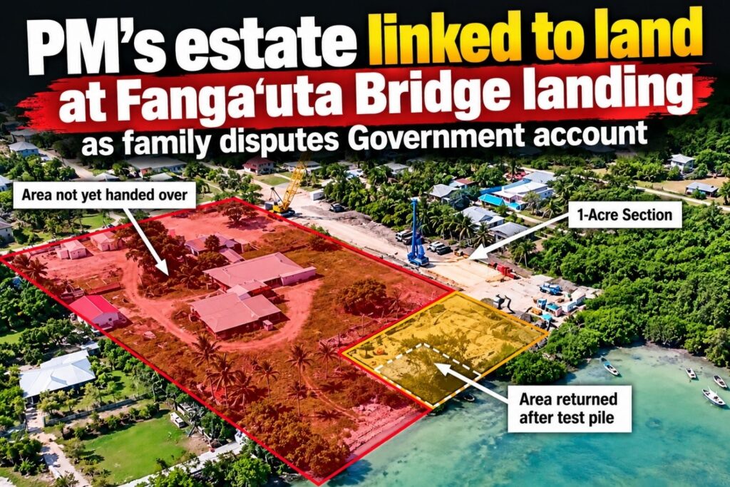
An aerial photograph dated 30 November 2025 marks an area not yet handed to the contractor. A separate area on the same photo is labelled “1-Acre Section”.
The report says the contractor could not get into parts of the northern site because the land handover was not settled. Only temporary works could go ahead.
The photograph does not say whether this section is the same land as the Fauolo family’s complaint.
The route changes
As TIN reported in our first article, land problems stalled the project and the bridge route was changed in May and June 2026. A diagram in the ADB report says the route was reviewed “to avoid conflict with the land area” shown in the earlier aerial photo.
This is where the two accounts pull apart.
The Government’s diagram suggests the route moved to avoid the disputed area. The family says the opposite: that the route moved away from land first chosen for the project and onto land linked to the unsigned surrender.
The documents TIN has seen do not settle which is right.

Who made the decision?
The Ministry of Finance runs the project. The Ministry of Infrastructure carries it out. A Project Steering Committee handles technical oversight, with other Government committees above it.
On 4 December 2025, the report records a meeting with the Prime Minister about site access. At that time the Prime Minister was Dr ʻAisake Eke, who stayed on as caretaker after the November election. The Steering Committee first met five days later, on 9 December. McConnell Dowell briefed it on delays and how to deal with them.
Parliament elected Lord Fakafanua Prime Minister six days later, on 15 December 2025. The King formally appointed him on 18 December.
The public report does not name the committee’s members. It does not say who approved the new route.
Whether the Prime Minister took part in any decision about land linked to his estate is not known.
Who gets paid?
As TIN reported, the project set aside about TOP $5.73 million for land and compensation.
The ADB report names land access and compensation as main causes of delay. It does not say whether compensation for the disputed 1.44 acres was assessed, approved or paid, or to whom.
This is important, that when a public official holds a financial interest in land affected by a public project, there should be a clear record of how that conflict was handled.
Asking that question is not an accusation. TIN has found no evidence of wrongdoing.
The family’s claims
Mrs Fauolo has also said a Ministry of Lands staff member told her the route change came on the Prime Minister’s instructions.
TIN has not been able to confirm this.
The Government’s 8 July letter to Major Fauolo and the Steering Committee minutes may shed light on how the decision was made.
Right of reply
For our earlier investigation, TIN asked the Prime Minister’s office why the route changed, what the status of the Fauolo land is, and whether he had any role in decisions on the project. We also asked how his roles as Prime Minister and estate holder are kept separate. No reply was received.
For this story, TIN again contacted the Prime Minister’s office. No response had been received by the time of publication. The Prime Minister is welcome to respond, and TIN will publish his reply in full.
TIN understands that other Government ministries involved in the project have been told not to comment on the matter.
Key dates
Date | What happened |
7 Sep 2006 | Fauolo family applies to surrender land for second son Roy |
10 Jan 2007 | Cabinet approves the surrender (Decision No. 49) |
30 Nov 2025 | Aerial photo marks land not handed over and a “1-Acre Section” |
9 Dec 2025 | First Bridge Steering Committee meeting |
15 Dec 2025 | Parliament elects Lord Fakafanua Prime Minister (appointed 18 Dec) |
May 2026 | New route confirmed. New survey shows Lot 24 at 3.80 acres |
Jun 2026 | New route finalised |
14 Jun 2026 | Major Fauolo lodges complaint |
8 Jul 2026 | Government replies: land reverted to estate holder |